Tokharistan and the Middle Ages …
At the end of the 4th century and the first quarter of the 5th century, under the onslaught of nomadic tribes — Ephthalites, Hionites, and Kidarites, the mighty Kushan Empire collapsed, and in the 5th century a new entity — Tokharistan — appeared on the political scene of the Middle East. For the first time the name Tokharistan appears in the Chinese text of the Buddhist work Vibhāsa-śāstra, dated 383, where the inhabitants of the country Ton-k’iü-le are mentioned. In another Buddhist source, the Māhāmayuri, in a list of yakshas, mentions the yakshas of Tūhār, by which is to be understood the people of Tokharistan[1]. More specific information is available from Bei-shi (Wei shu), dating back to 450 A.D. He not only mentions the new domain, but also gives its boundaries. In the north this possession bordered with Si-wan-jing (Samarkand Sogd), in the west — with Bo-sy (Iran), in the south — with Fan-yang (Bamiyan), and in the east it was limited by a mountain chain, by which is meant, apparently, Badakhshan[2].
In fact, early-medieval Tokharistan of Arabic-speaking sources to a large extent, territorially corresponded to ancient Bactria. At that period it was the territory of the Kidarite state, which in the 4th century AD split into two parts. The northern part included Southern Tajikistan and Northern Afghanistan, and the southern part was limited to the part of Northern India. Hence, the name Tu-ho-lo was the name of the main part of the Kidarite state[3].
In another Chinese source — the history of the Tang dynasty «Xin-tan-shu» (618-907 AD) also occurs the name of the region in a transcription close enough to the form that was fixed for it, namely — Ku-tu-lo. In addition, there are other, but also close transcriptions of this word — Duholo, Tuhulo, Tuholo. The Tang chronicles characterize this area as follows: «Tuholo… It is located to the west of the Pamirs and to the south of the Wuhu River, occupies the lands of the ancient state of Da-sya (Bactria). They live mixed with Yada (Eftalites)»[4].
A.M.Belenitsky, with reference to V.Minorsky considers that the word Tukholo of Tocharian or Ephthalite origin, and it should have arisen in V-VI centuries A.D.[5] Therefore, it is likely that first the invaders, and then settled on the new land Ephthalites and gave their name to this territory. A.M. Mandelstam also believes that: «the name Tu-ho-lo is a transcription of ‘tokhara'»[6]. The Ephthalites themselves, being the dominant-forming element, continued to lead a nomadic way of life, and the subordinate areas paid them tribute, but the power in these possessions still remained in the hands of the old, local dynasties.
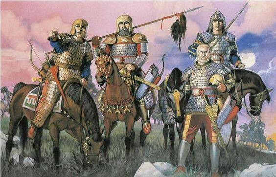
The following information about Tokharistan dates from the late 6th and early 7th centuries. By this time the state of the Ephthalites, who replaced the Kidarites, had been defeated by the joint actions of the Turkic Kaganate and Sassanid Iran. At division of «Ephthalite heritage» to Khosrov I Anushirvan several possessions, including Tokharistan, were given to him. But the Ephthalites continued to play a major role in the events of this period and invariably acted as implacable opponents of Iran. The last active actions come to the campaign of the Sassanid troops to Tokharistan in 616-617, where according to the sources continue to live Ephthalites[7]. Taking advantage of this struggle, the Western Turks under the kagan Tun sheyu (618-630) subordinated Tokharistan to their power, the administration of which was appointed his son Dadu Shadu. A.M.Mandelstam considers that Dadu Shad was, obviously, the founder of the dynasty of rulers of Tokharistan, who bore the title of yabgu, as all the data on the later period testify to the hereditary nature of this position [8]. According to E.V.Rtveladze, the possessions of Tokharistan were only nominally subordinated to the Turkic yabgu, as there are no Turkic names and titulature on the coins of this period[9]. This is confirmed by Armenian sources analyzed by K.I.Trever: «The Turks defeated the Persian army, turned Dotayan (the head of the detachment) in flight, and themselves raided to the limits of Rey and the region of Aspahan, robbed the whole country and returned to their camp, After that from the great khakan came the order to Chembukh (Turkic commander) and they crossed again the river (Amu-Darya) and went to their places»[10].
The Chinese traveler Xuan-Jian, who visited Central Asia in 630, wrote in his «Notes on the Western Countries» that from the Iron Gate one enters the Tukhol States (Baysun Range). It is bounded on the east by the Tsunlin (Pamir), on the west by the lands of Botsisa (Persia), on the south by the Great Snowy Mountains, and on the north by the Iron Gate. The great river Fochuhe flows westward in the middle of their dominions. Since that time, when the family of rulers was cut off, the leaders began to compete, usurp the post of ruler and by the impregnable valleys were divided into 27 states [11]. From them the largest were: Termez, Chaganian, Aharun (Shuman), Huttal, Vakhsh, Kumed and Kabadian, Shugnan and a number of areas lying to the south of Amu Darya.
In the Arabic-Persian historical tradition (at-Tabari, al-Khwarizmi, al-Balazuri, Ibn al-Asir) «Tokharistan» is interpreted in a broader sense — as a historical and cultural area of Khorasan, as the main habitat of the Ephthalites, covering almost all areas of ancient Bactria (Tokharistan), located between the Pamir Mountains and the Murghab and Gerirud rivers and the mountain ranges of the Hindu Kush and Hissar (i.e. the territories now located in the south of Tajikistan, Uzbekistan and Northern Afghanistan), more gravitating towards Balkh[12]. i.e. the territories now located in the south of Tajikistan, Uzbekistan and Northern Afghanistan), more gravitated towards Balkh[12]. Perhaps, originally this country was called Tukhara, about what among Arab geographers only al-Balazuri testifies that «Later al-Ahnaf went to Balkh, the capital of Tukhara…»[13].
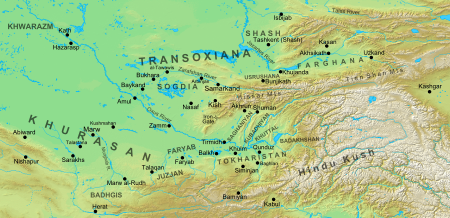
In Chinese sources of the 6th to 7th centuries, the term «Tu-ho-lo», i.e. «Tokharistan», occurs in two meanings. According to the Chinese chronicle «Tangshu», the country of Tu-ho-lo occupied all the lands of the ancient country of Da-hya, i.e. Bactria[14]. The same source mentions a separate possession of Tu-ho-lo, located south of the Amu Darya between Balkh and Badakhshan. В. V. Bartold believed that Tokharistan in the broad sense included only the areas located in the upper reaches of the Amu Darya and its tributaries on both sides of the main channel.[15] However, in the sources of the IX century, Tokharistan in the broad sense also includes cities located west of Balkh, such as Juzjan, Zamm and Faryab. Ninth-century sources mention early medieval Tokharistan with Balkh as its center. In the south, the borders of Tokharistan ran along the Hindu Kush mountains, in the north along the Hissar range, in the west near the Kabakli tugai located 150 km west of Amul (Chardzhou), and in the east along the Pamir mountains.
The term «Tokharistan» in the Middle Ages was also used in two meanings. In the narrow sense, this name meant a small region located between Balkh and Badakhshan, and bounded in the north by the Amu Darya, and in the south by the Hindu Kush mountains[16]. In a broad sense, Tokharistan was understood as the entire territory of ancient Bactria, which was bordered in the north by the Hissar range, and in the south by the Hindu Kush mountains; in the east its border ran along the Pamir mountains, in the west — along the middle course of the Amu Darya. In general, early medieval Tokharistan corresponded territorially to ancient Bactria to a large extent[17]. Currently, this territory is part of the western part of Turkmenistan, southern parts of Uzbekistan and Tajikistan and the northern part of Afghanistan.
In the Early Middle Ages (VI-VII centuries), Tokharistan was temporarily part of the Western Turkic Kaganate. The political power of the Turks extended over almost the entire territory of Central Asia, but economically and culturally the country did not represent a unified whole and was divided into many small semi-independent possessions whose rulers were actually independent[18].
Early medieval Tokharistan was divided into many small semi-independent possessions. This historical area was culturally and economically closely related to Sogd and India rather than Sassanid Iran. After 618, when Tardu-shad, son of the supreme Turkic haqan, was appointed supreme «yabgu» of Tokharistan, there was a mass migration of Turks from Semirechye to Tokharistan.
In the middle of the 7th century, Arabs appeared on the borders of Tokharistan, having conquered Iran and part of Khorasan by that time. According to at-Tabari, the first Arab campaign to Tokharistan took place in 642-643, when the Arab commander al-Ahnaf ibn Qais, pursuing the last Sasanian king Yezdigerd III, came from Merv and approached Balkh[19].
By 652-653, the Arabs had already conquered almost the entire territory of Tokharistan south of the Amu Darya and even crossed into Maverannahr[20]. In all conquered cities the Arabs concluded treaties according to which local rulers had to pay them annual tribute. But the inhabitants of many regions and cities often violated the concluded treaties and refused to pay tribute to the Arab viceroys. Therefore, the Arab conquerors repeatedly made punitive campaigns against the rebellious inhabitants of Tokharistan and actually reconquered their territories.
Local residents of Tokharistan repeatedly united their efforts in the struggle against Arab conquerors. In Tokharistan, one of the largest uprisings of the locals against the Arabs took place under the leadership of Nizak Tarkhan in 710-711, brutally suppressed by the Arab commander Kutayba ibn Muslim.
In the ninth and tenth centuries. Tokharistan was already part of the centralized Samanid state, although Samanid power in some regions of Tokharistan was nominal. Thus, in some regions of Tokharistan was established the power of local dynasties that enjoyed the patronage of both the Samanids and the Abbasid caliphs. At that time Tokharistan was characterized by the fact that almost every city had a mint that issued copper coins on behalf of local rulers. There were mints even in such relatively small towns as Andicharag, Rasht, Valvalij, Jirm, Kishm, Zebak and others. All these coins were issued according to the uniform pattern of caliphate coins with Arabic inscriptions, which contained the names of Samanid rulers and their viceroys.
At the end of the 10th century, the central power of the Samanid state weakened. In fact, some peripheral regions ruled by local dynasties became independent. After the fall of the Samanid dynasty, many local rulers went to serve the Karakhanids, and other regions of Tokharistan, except Saganian, came under the rule of the Ghaznavid dynasty, and from the second half of the XI century went to the Seljukids.
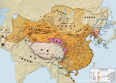
At the beginning of the 13th century, the entire territory of Central Asia, including Tokharistan, was conquered by Genghis Khan’s troops and the term Tokharistan was no longer used.