The time and circumstances in which the term «Desht-i-Kypchak» appeared, which we have replaced with «Kypchak el» or «Kypchak Khanate», have always been ambiguously interpreted in historical literature. Some authors believe that this term originally appeared in Persian historiography in the XIII century. However, Academician V. V. Bartold, known for his scrupulosity, in his work with primary sources challenged the validity of such a point of view, referring to more reliable information. The term «Desht-i-Kypchak» («Kypchak steppe»), according to him, instead of the former term «Guz steppe» is found already in the author of the XI century, the Persian poet Nasir-i-Husrau. Hence, in the academician’s opinion, it follows that this term was established in the historical period when the migration process of the Kipchaks reached its apogee, i.e. when they, displacing the Oguzes in the southern and western directions — in the Volga region and in the South Russian steppes — successfully replaced the Pechenegs. With the rise and strengthening of the Kipchaks’ influence, which meant their dominant role in the political life of Eastern Europe and Central Asia, the steppes from the Irtysh to the Danube as the territory of the Kipchaks began to be quite reasonably meant under Desht-i-Kipchak.
Data on the Kipchaks and the land of the Kipchaks are available in Russian chronicles, in the works of European travelers, and in the notes of Oriental authors. According to experts, the term «Desht-i Kipchak» is most widespread in Persian written sources, especially in the XIII-XIV centuries, as a result of the displacement of the Arabic language by Persian.
In the collected sources of V.G. Tizengauzen, the toponym «Desht-i Kipchak» (generalized — «Kingdom of Kipchak», and we would add — «Kipchak Khanate») occurs quite often. A careful reading draws attention to the fact that in the earlier Persian chronicles of the period of Genghis Khan’s conquests the term «Desht-i Kipchak» is mentioned in the meaning of the main ethnogeographical region of the Ulus Juchi along with other regions of this medieval state. Gradually, the familiar geographical term «Desht-i-Kipchak» began to be used by some Persian historians with some semantic connotation, giving it the name of the state.
It should be said that this circumstance later acquired the features of a peculiar historiographical tradition, which played its role in historical research. However, in modern historiography, the term «Desht-i Kipchak» has long been used more as the name of a geographical area than as the name of a state.
In the geographical sense, Desht-i-Kipchak is understood as a historical region of Eurasia, which was the Great Steppe that stretched from the mouth of the Danube to the lower reaches of the Syr Darya and Lake Balkhash. In Old Russian sources, this region is also called the Polovtsian Steppe, which was inhabited by the peoples of the Kipchak group.

Desht-i-Kypchak is a historical territory, which is now divided between three states: Russia, Ukraine and Kazakhstan.
Official historiography claims that in the pre-Mongol era (meaning Batyi’s invasion) the population of Desht-i-Kipchak did not represent a single ethno-political community, differing both in socio-political organization and in methods of economic activity.
The history of the Kipchak country still remains almost unknown to modern historians not only because of the lack of sources. For a long time the Kipchaks were simply ignored by historical science. Recently, however, information has been accumulated, although the interpretation of these materials is far from simple. There are too many contradictory interpretations, sometimes mutually exclusive.
According to Academician V. V. Trepavlov, in recent years, some provisions have begun to mature, which, perhaps, will allow a new look at the history of the Eurasian steppes of the first one and a half millennia AD. In all fairness of the historian V. Trepavlov’s judgment that the Persian book concept «Desht-i-Kypchak», «having appeared within the framework of the Muslim geographical tradition and replacing the former «Mafazatal-guz» and «Dasht-i-Khazar», denoted one of the regions of the sixth «climate»»», we cannot agree with his statement that it cannot serve as a name of any community of tribes and peoples. Certainly, for foreign observers all inhabitants of the steppe country, as a rule, appeared as Kypchaks (or Kumans). This ethnicon, as V. Trepavlov unequivocally states, encompassed a mass of tribal associations, different in origin. Nevertheless, the name «Kypchak» was given to these associations by the latter because of their dominance. It can be said that quite a significant part of tribes used the word «Kypchak» as a self-name. Therefore, there can be no doubt about the dominant role of a significant Kipchak part, as there is a huge amount of evidence about the apparent abundance of Kipchaks on this territory during a rather long historical period.
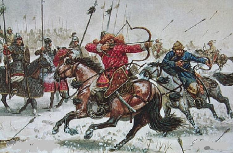
Meanwhile, we have every reason to speak about the vast state of the Kipchaks, which they created from the XI century, coming from the banks of the Irtysh and occupying the territory of modern Kazakhstan and the South Russian steppes. In the X century they occupied the territory of present-day North-Western Kazakhstan, bordering in the east with the Kimaks, in the south with the Oguzes, and in the west with the Khazars. Due to the demographic explosion, the main cause of which was the overpopulation of the steppes, the Kipchaks were forced to move from their native places in search of new lands and pastures for cattle. As a result, the Kipchaks again encountered the Pechenegs.
By this time the confrontation between the Pechenegs and Byzantium had reached such a level that, unable to cope with the incessant onslaught of the Pechenegs, the Byzantine emperor turned to the Kipchaks for help. One of the pragmatic Kipchak soltans decided to support the Byzantines in order to deal with a long-standing rival in the steppe. As a result, the Kipchaks, having defeated the Pechenegs, occupied the territory from the western spurs of the Tien Shan to the Danube.
Parts of the defeated Pechenegs together with Turkic-speaking Alans or Ases of the North Caucasus, Bulgarians and Torks formed a political alliance with the Kipchaks. Such polyethnic formation became the basis, the core of the future Kipchak state, where Kipchaks played an organizing political role in the formation of a new political community. That is why we not only refer the IX-XIII centuries to the Kipchak period, but also include the entire XIV century and the heyday of the Golden Horde, which gives us the right to confidently use the historical sources of the so-called «Golden Horde» period.
These are mainly observations of Arab and Persian historians and travelers. However, the geographical data reported by them can be attributed to the XIII century without a stretch, since the size of the state and its main components up to the second half of the XIV century did not undergo significant changes. This is also confirmed by the reports of Plano Carpini. True, in his attempts to summarize the territory of the Golden Horde he does not manage to finally recreate a complete picture of the lands of the state. But here we are attracted by details of another plan. In his endeavor to determine the summary list of peoples, which he cites, an interesting fact is revealed. At different times inhabiting vast areas of Europe and Asia and subject to the Golden Horde khans, according to Karpini, are, nevertheless, Kipchaks. He mentions only «the country of the Comans» (as the country of the Kipchaks was called in the West) with four rivers: the Dnieper, the Don, the Volga and the Yaik. As is known from the Cumans’ time, these rivers had already been considered Kipchak rivers for several centuries by that period.
It was undoubtedly a fully formed state with specific borders and inhabitants. According to the testimony of Guillaume Rubruk, in the very early period of the Golden Horde, the western borders extended «from the mouth of the Tanaid (Don) to the west, to the Danube», where everything belonged to the Kipchaks, as well as «beyond the Danube, in the direction to Constantinople».
The scale of the Kipchak state can be judged from written sources cited by Arab and Persian historians. In their descriptions «Desht-i-Kipchak» extends in length by eight and in width by six months of travel. Some reduced it to six months in length and four months in width, which, however, does not diminish the scale of the territory at all. There are, for example, in sources such descriptions of space: «…from the sea of Constantinople to the Irtysh river in length for 800 farsakhs, and in width — from Babelebvab (Derbent) to the city of Bulgar, i.e. approximately for 600 farsakhs».
One of the most detailed descriptions of the limits of the Golden Horde belongs to the author of the first half of the XIV century. al-Omari, which he compiled on the basis of inquiries of merchants and diplomats who visited it. Describing in general the territory of the state, al-Omari gives the names of its most famous cities and provinces. Among them, for example, he names cities known since the times of Cumans (Kipchak) domination: Khorezm, Sygnak, Sayram, Yarkend, Jend, Saray, Majar, Azak, Akchakerman, Kafu, Sudak, Saksin, Ukek, Bulgar, Derbent, as well as the provinces of Siberia and Ibir, Bashkird and Chulyman.
Soviet scientist V. L. Egorov in his historical and geographical study, referring to al-Omari, writes that as an additional characteristic of the total area of the state can be used the names of the rivers flowing here: Seyhun (Syr Darya), Jeyhun (Amu Darya), Danube, Itil (Volga), Yaik (Ural), Don (Tan), Torlu (Dniester). The cities listed by al-Omari are scattered throughout the territory of the state — from the limits of modern Kazakhstan and Central Asia to the Western Black Sea region. The easternmost outskirts of Desht-i Kipchak is named the region of Chulyman, which was located in Siberia. It attracts attention that the westernmost region is not clearly defined, although the Danube River is mentioned. Danube. Preliminary to our study, we would like to emphasize that the territory of the lower Danube has its own reasons to be given special attention in this paper. In the future we will return to this peculiarity when defining the western part of the Golden Horde. As the northern limit of the state are named g. Bulgar and the region of Bashkird. The southern border is marked by the city of Derbent.
The following detail is also noteworthy. The northeastern and southwestern lands where the Russian population lived, a number of historians consider separately from the main lands of the state of Desht-i-Kipchak. In this case, it means that modern researchers separate the lands inhabited by the Kipchaks or peoples close to them by language, on the national basis. Hence their own assumptions are made, which have little in common with historical reality. It is asserted that the territories of the Russians were subjected to tribute as if on bonded terms and at the same time existed in the position of semi-independent lands. This stereotype, containing an obvious contradiction and passed from generation to generation, completely clouds the view of historical realities. Everyone in the state paid tribute, or, in modern language, taxes to the state treasury, including the Kipchaks themselves. Only the subjects of the state could be taxed, respectively, the northeastern and southwestern lands were part of a single administrative-state territory. Consequently, these lands formed the territorial basis of a single state. The core of the huge state territory was the Black Sea, Caspian and present-day North Kazakhstan (there was no such name then) steppes up to the Siberian river Chulyman.
At the time of seizure of the khan’s throne of Kypchak el (state) by Batyi Khan, the centralization of state power in the country was just about to be completed.
Long before the Chingizid invasion, the Kypchak state consisted of two main groups, closely connected with each other: the western group — between the Dnieper and the Dniester-Danube interfluve — and the eastern group — from the Dnieper to the Volga and the Yaik. The concentration of political power took place in the western part of the Cumans steppes, where Khan Bonyak, who later received the title of «Great Khan», ruled.
For our study, as we have already mentioned, such a detail as the Lower Danube lowland is of fundamental importance. For a long time there was a confrontation between Batyi’s forces and the official power of the Kipchaks, by that time already inherited by Khan Koten, a descendant of Khan Bonyak. As a result, the left bank of the Danube was subjected to prolonged plundering. The long stay of Batyi’s rearguard detachments in the Lower Danube Lowland was connected with the fierce resistance of the troops of Khan Koten, whose headquarters was located in the Lower Danube Lowland in the Prut-Dniester interfluve, in his ancestral estate — ulus. This is exactly the territory, which in history is known as the fiefdom of the famous Nogai Temnik. Even before the birth of Nogai, these vast lands of the family estate will be transferred to Mangysh — the eldest son of Soltan Koten. And Nogai, apparently, becomes the owner of these lands after Mangysh.
For the final victory Batu needed to depose Koten Sutoyevich. There is a widespread opinion in the literature that Batyi repeatedly offered Khan Koten to give up the battle and become his vassal. And Khan Koten allegedly rejected such a proposal. As further events show, Batyi strengthened his power, overcoming strong resistance from the local population, primarily Kipchaks, and could not yet dictate his terms. For a long time he avoided an open battle with Koten, resorting to bribing a certain part of the Kipchak nobility, insidiously and sneakily striking in the back. His favorite method was poisoning the largest and most influential representatives of the Kipchak and Russian aristocracy.
Nevertheless, Soltan Koten retained the Prut-Dniester interfluve for several years, controlling the united troops. For a long time Koten managed to successfully repel treacherous onslaughts of Batyi’s troops and his allies from among opposition Kypchak biys and Russian princes of western Russia. Having exhausted the forces of Batyi’s armies, he nevertheless crushed the Kiev opposition. Kiev has been ruined and plundered. However on restoration of forces of the Western Russia have been thrown means of the Roman Pope, first of all in the person of the Teutonic order. It was clear that in the conditions of waging war on two fronts, the chances of saving the main forces are not high. Koten decides to move his bet on the territory of Hungary after he manages in Kypchak Khanate to organize a network of underground resistance associations from among the loyal to him Kypchak princes and irreconcilable magicians of the union of the tribes of the Ases. Having made sure that the enemy could not pursue his troops, Khan Koten with a numerous army of forty thousand tents crossed the border of Hungary, where at that time the king was his son-in-law.
The remaining part of the population of Kypchaks with Ases and inhabitants of East Russia continued to lead resistance.
On the territory of Hungary Kipchaks restored forces and did not leave intentions to return to the native land at any point. The death of khan Koten, about what we will tell below, for some time delayed the decisive moment of return. After the death of the outstanding soldtan Koten, whom the Nogai people still honor and respectfully call Koten-batyr (Koten the Great), his army was led by the early formed military leader Akkas, grandson and pupil of the soldtan Koten, known in world history and among the people under the name of Nogai.
Akkas very early showed himself as a talented strategist. He managed to coordinate his decisive march from the territory of Hungary to the Prut-Dniester interfluve with the people’s militia in his homeland, in the Kypchak Khanate of Desht-i-Kypchak. As a result, he ousted the Chingizids from his ancestral ulus forever. For the rest of his life he kept the ulus under his rule. None of the khans of the Golden Horde, while Akkas was alive, managed to extend his power to the possessions of Akkas-Nogai.
In the historical literature there is an opinion that this ulus was allegedly transferred to Nogai by the highest decision of the supreme power of the Golden Horde. The information that such an important issue in the history of the Golden Horde was decided at a special kurultai is not confirmed by any explicit or implicit sources. They judge about it exclusively on the later assumption of Carpini, in which the real borders of nomads, established as a result of such division, are already fixed.
But at the same time historical science does not have any written evidence that these lands were given to Nogai by the Chingizids. Not only that, at Karpini western borders of already Golden Horde lie between Prut-Dniester interfluve and Golden Horde. Carpini, for example, does not mention at all about the belonging of lands beyond the Southern Bug and Dniester to the Golden Horde, to what we paid attention at the beginning. Karpini’s silence about the Prut-Dniester interfluve and the lower reaches of the Danube just confirms that this area was not under the rule of Batyi and other Chingizids.
Some researchers emphasize that the sources do not contain information about who exactly belonged to this ulus in the 40-50s of the XIII century. And all the matter is that at that time Soltan Koten with his army was defending his lands from Batyi’s raids. It is also known that in the 60s this ulus was owned by Nogai as a full master. About occurrence Nogai on the western edge historians only guess, putting forward various versions.
Arabian authors inform that Nogai’s settlements were on Danube in area of city Isakcha. Byzantine historians confirm the same, reporting that Nogai «had a residence on the other side of the Istra», i.e. in relation to Byzantium — north of the Danube. The core of his possessions was the Prut-Dniester interfluve.